
Getting ready to assemble the book now, which means maps! Or…well, a map. Unlike Book 2, when I did a large split-map because the characters were ranging all across the Imperial Heartlands, this time I think there will be just one map, vertical along one page. That will mean tablet- and e-reader users will have to tilt, but it will save some space, since the action takes place in a more limited area.
Here it is, then:

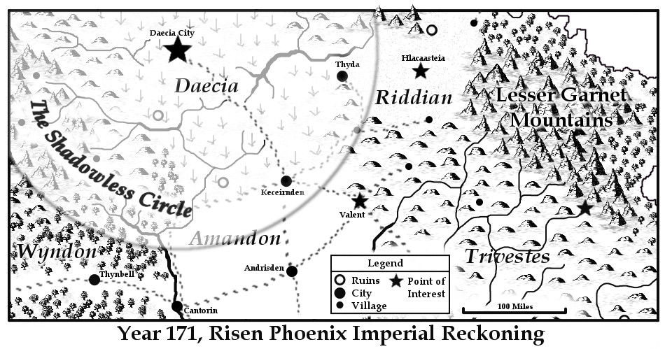
Alas, the books — both physical and digital — will probably need to use the black & white version, because of printing constraints. It’s not as attractive, but I think it gets the job done:
One step closer to publishing!


your maps are so lovely
Love the maps. I need to work on mine.
Thanks! It took a lot of time and effort to get the base maps done, but now I can rest on my laurels and just tweak a bit here, snip a bit there, for situationally relevant stuff. It’s very useful.
Definitely useful. I must look more.
Nice maps. Do you use the color version in your ebook? I like the color renderings so much better. I do my own maps and have problems with resolution when I insert them in print books. I use campaign cartographer, which makes great maps, but they’re just not crisp. Thanks for sharing this.
I’m considering using the color version this time — in the previous two books though, I used the black and whites. File size can be an issue in KDP, but looking at it now, I think it might be worth it to switch out. As for crispness, the loader for the print version always complains about DPI, so I usually have to fiddle around with size and resolution for a while before it’s satisfied, but the maps in my print books look pretty good. I really would recommend GIMP 2 just as an all-around art tool.
Thanks so much for the suggestion. I’m a technological novice, so sometimes this stuff just eludes me.
So… where’s Akarridi?
Not pictured. Somewhat below the Legend box. I just wanted to show the action-relevant parts of the story, and since the other half of the story doesn’t leave Bahlaer…