
As a detail-obsessed individual who always liked geology and took a few courses in college, I’ve always tried to make the tectonics of my world somewhat realistic. Since I started making the properly-to-scale maps of the main continent, however, I realized that the ‘known world’ is just a small portion of the planet…and that made me want to map out the rest of it.
So I made some global maps.
Mind you, these are rough drafts — none of the other continents or islands have been particularly defined in their shape or characteristics. All of this has been built upon the map of the tectonic plates under the known continent that I made previously (but did not upload), only extended to fill a whole globe’s worth of space.
The maps are also ridiculously large because I’m working on them at 50% scale from the original ‘known world’ map, so I’d advise just enjoying the thumbnails until I can toss up smaller versions.
First, this is the plain continent-map, with the ‘known world’ in the upper middle:

I knew from the start that almost the entirety of the ‘known world’ continent is above the equator, with just a sliver of it below, so when I was positioning it on the larger canvas I drew some equatorial guidelines. I also sized the planet with a bit of an equatorial bulge, as they tend to have, so that the distance around the poles is shorter than that around the equator.
With those guidelines in place, I decided to mark out the current location of the polar ice caps, as well as the previous extension of the ice caps during Halci’s ice age when the Light God recoiled from the world.
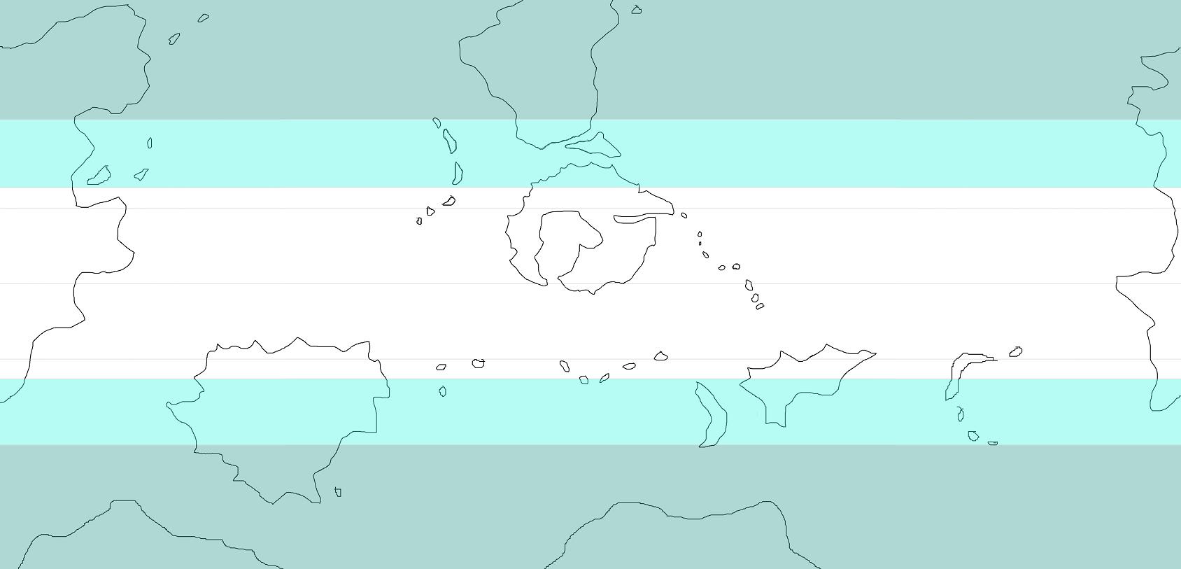
Dark blue is the current ice cap coverage, with light blue the previous ice cap extension — thus also the limit of glacial moraines and other such land features.
But I had mentioned tectonic plates earlier…
After a whole lot of reading and staring at tectonic plate maps of Earth, I came up with the plates below. Halci is smaller than Earth but extremely active, so it has lots of little plates in addition to the standard large continental plates. In fact, most of the continents are being formed by the collision and fusing of these little plates.
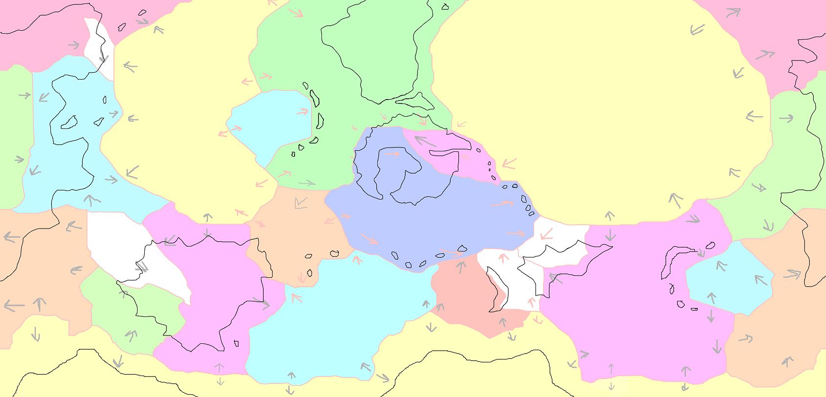
From here, you can see that the ‘known world’ continent is a product of three colliding plates. They originally were two plates, with the small pink plate a part of the larger blue plate, but during the Sealing there was enough pressure put on that older plate that it fractured along a weak point — which became the Rift. The new pink plate is being thrust northwestward, so it isn’t separating from the blue plate; instead, it is being forced against/on top of the blue plate, causing a superficial subduction zone with severe mountain-building and earthquake activity.
The Rift continues onto the green plate above as a land-deformation due to the thrust, not as an actual continued fault-line, so the part of the Rift to the north is fairly stable. The green plate’s contact with the blue plate, however, created the Thundercloak and Khaeleokiel mountain ranges long before the Rift, so there are huge stresses now in the area where those three plates converge — which happens to be very near the Khaeleokiel Range’s big volcano Aekhaelesgeria.
Speaking of subduction and collision zones, I also delineated the main zone-types between all the plates:

In this map, the blue lines are subduction zones, where one plate is being pushed down beneath another so that it can melt into the mantle. The red lines are mid-oceanic ridges — plate-building zones where new crust is extruded from the mantle. The grey zones are places where plates collide but neither subduct nor extrude, either creating faults or mountain-building areas.
Subduction zones are a main cause of volcanic island-chains (on the up-side, not the subducting side), thus why there are little arcs of islands alongside lots of the blue lines. On the other hand, there is rarely any continental surface near a mid-oceanic ridge.
I’ve decided that the red line just southwest of the ‘known world’ continent did not exist until recently; the plates it divides used to be one. That means that in the colored plate map above, the blue plate and the orange plate were a single plate. However, either the Sealing or an earlier tectonic process tore the two plates apart and created a new mid-oceanic ridge, adding pressure to the blue plate’s already strong eastern drift.
Anyway, according to my ice age map, I have a few decently-sized landmasses that used to be almost completely covered in ice but are now quite habitable, and one extremely large landmass with a central area that was never in danger. I also have a variety of archipelagos in different temperature-zones. While none of this will be impacting the current story, it gives me a good basis for the future.
I’m also planning to make a proper globe by wrapping this map around a ball or something and slicing up the areas around the poles so they can fit properly, since a 2D map can only go so far in expressing a 3D object. Thus the dark-blue top and bottom of this map will be altered, making the landmasses there just sketchy first ideas.
This is apparently what I do with my spare time.


omg OCD much? lol
admittedly – i do the same thing sometimes. >.>
You are such a geek, I love it!
I’ve got a map like this on paper. Eventually I’ll get it up. I must read through your world-building posts!